
Description
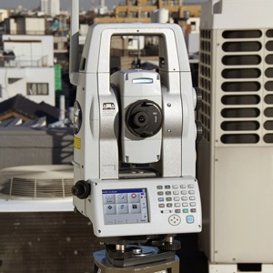
Topcon IS-03 Imaging Station
The power, accuracy, and speed of a total station with the auto-scanning capabilities of a laser scanner; Topcon’s IS takes material management, as-built design, and structural/environmental monitoring out of the clouds and puts it at your fingertip.
A new way to scan
Topcon’s IS combines the best of two worlds, advanced imaging and high-accuracy surveying, incorporating real-time field imagery with spatial data. The IS-3’s powerful functionality is controlled using Topcon’s exclusive ImageMaster™ software that produces “photography with dimension”, a revolutionary and cost effective alternative to laser scanning.
Long Range Scanning
Nobody can provide the combination of laser scanning and robotic surveying like Topcon with the IS. With the long non-prism range of up to 6,500 ft. (2,000m), the robotic instrument can now scan long distances as well. Mining and monitoring applications can be accomplished with the IS.
Remote Networking
The IS has WLAN capability and can be controlled remotely. Imagine sitting in the comfort of your office or vehicle and being able to scan, measure, control, and see what the IS is seeing.
Touch Drive – Turn and select a point on screen
Simply touch the screen image to drive the cross hairs where you want. For the highest degree of data accuracy, clarity of image is key. That’s why Topcon incorporates telescopic zoom with an LCD. Using the telescope, pinpoint features to be measured or monitored precisely up to 6,500 ft. (2,000m) away.
Continuous Monitoring
With a WiFi connection, image-based monitoring can be done continuously and remotely. Whether done with mounted prisms or reflectorlessly, this monitoring function compliments the everyday use function of our robotic surveying. The IS-3 features Bluetooth® and WiFi technology making continuous monitoring easy.
Whether monitoring a mine, creating volume calculations, creating an area topo, structural/environmental monitoring, or even documenting as-builts, Topcon’s IS-3 provides a value-priced alternative to laser scanning.
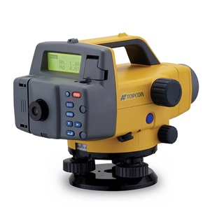
Sample Robotic System in one Case
— IS-3 1”, 3” or 5” instrument
— Charging Cradles
— FC -250 Controller with TopSURV
— WT-100 System
— A7R4 360° prism
— Li-Ion Batteries
— TopSURV on Board for IS
— ImageMaster (Remote Control
and Office Processing software)
— Manuals & Utility software
SPECIFICATIONS
Your local authorised Topcon distributor is:
grafit-werbeagentur.de
T426EN-English-A
IS-3 1” IS-3 3” IS-3 5”
ANGLE MEASUREMENT
Method Absolute Reading
Minimum Reading 0,1 / 0,5 mgon 0,2 / 1 mgon 0,2 / 1 mgon
0,5” / 1” 1” / 5” 1” / 5”
Accuracy 0,3 mgon / 1” 1 mgon / 3” 1.5mgon / 5”
Tilt Correction Dual Axis
Compensating Range ±6‘
DISTANCE MEASUREMENT
Prism Mode
– Range 1 / 3 / 9 prism 3000 m / 4000 m / 5000 m
– Accuracy ±(2 mm + 2 ppm x D*) m.s.e.
Non-Prism Mode
– Short Range 1,5 m – 250 m
Accuracy ±3mm m.s.e.
– Long Range 5,0 m – 2000 m
Accuracy ±(10 mm + 10 ppm x D*) m.s.e.
Rapid scan Up to 20 Hz ±5 mm m.s.e.
EDM Laser Class Class 1 (IEC publication 825)
Automatic Tracking
Tracking Speed 15°/sec
Tracking Range 1000 m (with standard prism)
Rotating Speed 85°/sec
IMAGING
Cameras 2 x 1.3 Mp ccd, wide angle apparent resolution equivalence to 4.8 Mp
Image Speed up to 15 fps
USER INTERFACE – Feature recognition system
OS Microsoft Windows CE®.NET 5.0
Processor Intel PXA255 400 MHz
Screen 3.5” TFT Full colour touch-screen
Interface RS-232C / Compact Flash / USB(Type A,Type B mini)
Memory 128MB RAM, 2MB Flash ROM, 1GB micro SD Card

Reviews
There are no reviews yet.